from Rob Legg Yachts |
|||||
The Monte-Bellos… The A-Bomb islands of the North WestPart 3 - THE RUN FROM ONSLOW
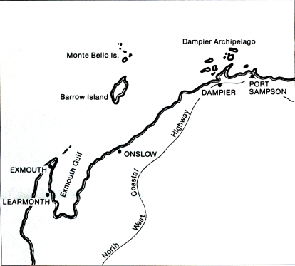
I was lucky enough to borrow a utility from the orderly at the hospital to carry supplies from the town (three kilometres away) to the creek. These included 40 litres of water, as I had in my ignorance presumed that water would be available at the jetty. It wasn't then but it is now. Some of the best advice I had been given applied to our departure from Onslow. Cross currents of up to six knots have been recorded in the Mary Anne Passage between the southern tip of the shoals which protrude for 18 miles south of Barrow Island and the small Islands scattered along the coast. The advice to arrive at the Passage at slack tide was well founded, as after a 1400 hours departure from Beadon Creek and a wonderful six hour spinnaker reach, the wind dropped after sunset and it was motoring time again. My chart of this part of the voyage, and for the next hours is a mass of crosses as I regularly took compass bearings of the three lights that are visible from the passage. This small area would be the best lit along the Western Australian coast and a night time passage has advantages over the more sunlit hours, especially as it allows a safer first light arrival at the Monte Bellos. The warning about the cross currents was most apparent even though we arrived in the Passage at slack tide. For the previous two hours we had been steering up to 30 degrees from our course line to maintain track as the tide seemed to be running more north-south than the chart's indication of east-west. As we approached North Sandy Island just after midnight, it was time to turn due north for the 40 mile run up the east coast of Barrow Island. For the second day in succession, the winds smiled upon us and within minutes of us turning north, a light southerly pushed us on our way, so nicely in fact that we had to drop the main to slow us down a bit so we would not arrive at the Monte Bellos too early. Two traps still awaited our arrival however. The first was the gas flares which are marked on the chart of Barrow Island. Don't try to use them as a navigation mark as they tend to be turned off and one, a mile or so away, relit at the most inopportune times, turning the most precise coastal navigation into a fool's nightmare. The second problem was our arrival at the Monte Bellos. The string of small rocks and islands that protect the southern reaches are very hard to distinguish from one another for the first time and it was only our lift keel that prevented something more embarrassing. Go back to Previous Page | Go back to First Page | Go on to Next Page |

